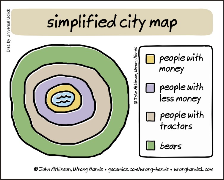
[…] of retweets of my response yesterday to a brilliant comic by John Atkinson (@WrongHands1 ), Simplified City Map, which I suggested was reminiscent of the classic chart by Ernest Burgess’ from his 1925 […]
[…] in April 2018[1] I blogged about a cartoon by John Atkinson, Simplified City Map, which I suggested was reminiscent of the classic chart of ‘Urban Areas’ by Ernest Burgess […]


I think you just depicted Atlantic City, New Jersey, Northern East Coast USA!
LikeLiked by 3 people
[…] Source: simplified city map […]
LikeLike
White area around the circle: bears with tractors.
LikeLiked by 3 people
…in theatres this summer
LikeLike
Sounds like a post-rock group
LikeLiked by 2 people
UK has no outer layer. No bears. Just people with tractors.
LikeLiked by 1 person
I can send you some bears from Canada
LikeLiked by 1 person
Great, I’ll DM you my address 🙂
LikeLiked by 2 people
In Canada, the outer circle would be populated by moose.
LikeLiked by 1 person
But you don’t know how Wrong hands MEANS bears .. it could be a hiresute homosexual.
LikeLiked by 1 person
I really LOVE that one. Great work!
LikeLiked by 2 people
That is us in Almost Iowa, caught between people with less money and bears.
LikeLiked by 2 people
Haha 😛
LikeLiked by 2 people
Absolutely brilliant. Reblogging
LikeLiked by 2 people
[…] https://wronghands1.com/2016/02/12/simplified-city-map/ […]
LikeLike
[…] Source: wronghands1.com […]
LikeLike
[…] https://wronghands1.com/2016/02/12/simplified-city-map/ […]
LikeLike
[…] by wrong hands […]
LikeLike
Reblogged this on Logbuch Labelizer and commented:
Das ist schon sehr simpel, aber cool.
LikeLiked by 1 person
Well done!
LikeLiked by 1 person
As an urban planner, I can vouch for the accuracy of your city map.
LikeLiked by 1 person
[…] of retweets of my response yesterday to a brilliant comic by John Atkinson (@WrongHands1 ), Simplified City Map, which I suggested was reminiscent of the classic chart by Ernest Burgess’ from his 1925 […]
LikeLike
[…] Figure 1. Simplifed City Map, copyright John Atkinson, Wrong Hands, published February 12, 2016: https://wronghands1.com/2016/02/12/simplified-city-map/. […]
LikeLike
[…] in April 2018[1] I blogged about a cartoon by John Atkinson, Simplified City Map, which I suggested was reminiscent of the classic chart of ‘Urban Areas’ by Ernest Burgess […]
LikeLike